A major motor insurance firm has compared local transport plans across the UK to understand the future of the city after COVID-19.
Admiral said that while cities across the world were already planning to transform their centres in response to climate change, COVID-19 has caused some to accelerate these plans and re-design spaces.
It argued decision-makers should commit to permanent infrastructure plans that make sharing the road safer for all users.
Admiral has analysed plans published by cities across the UK and ‘re-imagined’ what cities across the world could look like in the future. To help people visualise these changes, it worked with a designer to re-design images of 10 of the world’s busiest city centres.
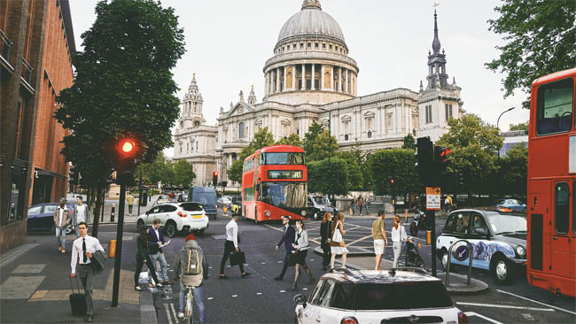
London, with St Paul's, as it looks now
Clare Egan, head of motor at Admiral, said: ‘The last few months have given us all a glimpse of the future with people opting for different ways to move around; from electric vehicles and e-scooters, to more traditional methods like walking and cycling.
‘We believe decision-makers in all cities should commit to more permanent infrastructure plans for more safe and sustainable travel for road users and pedestrians, and not just temporary plans. The world of transport is evolving quickly and cities need to evolve alongside it to meet demand and keep people safe.’
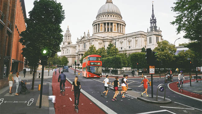
London and St Paul's in the future
Steve Brooks, executive director of external affairs at walking and cycling charity Sustrans, said: ‘Walking and cycling is an important part of urban resilience. It will play a key role in giving people the space they need to move around safely as we begin life in our new normal.
‘We’ve seen an unprecedented level of active travel investment during lockdown. This new urgency to invest in walking and cycling as part of the response to the pandemic has the potential to transform the way we move, the way we live and the impact we have on the climate emergency.
‘We’d love to see other businesses adopting Admiral’s forward-thinking approach.’
Admiral found that all cities who have shared proposed changes are prioritising pedestrians and cyclists by adding cycle paths, widening pavements, closing key roads and extending time at pedestrian crossings.
Many cities planned to increase signage (21%) including adding social distancing signs and management of social distancing measures – including in parks, at bus stops and at pedestrian crossings.
The research found that 37% of cities had planned to widen footpaths and pathways to allow for more space for pedestrians and for social distancing measures to be observed.
In addition, 15% of plans discussed the need to adjust pedestrian crossings, including making changes to remove the need for people to touch any buttons in order to cross the road, as well helping to prioritise pedestrians and cyclist at crossings.
Pedestrianisation of key roads to make them more accessible and suitable for people walking was also a feature in 15% of the plans. At least 10% of plans included details of one-way walking systems to enable social distancing measures to be observed.
A further 10% proposed removing street furniture to discourage pedestrians from sitting or congregating in certain spaces.
Pop-up and temporary cycle lanes, as well as expanded cycle lanes throughout the city centre, appeared in 31% of the plans analysed. Cycle lanes are also likely to be shared with e-scooters if legalised after the current trials.
The same number of plans (31%) included proposals to reduce, remove or repurpose parking in order to allow for widened footpaths or to stop the use of some parking bays.
New cycle facilities were referenced in 15% of plans, including the need to create cycle parking spaces for cyclists to safely store their bikes.
Over a quarter of the plans analysed (26%) included changes to bus lanes and bus stops, ranging from creating bus gates to re-organising bus lanes and infill of bus pull-ins.
More than a fifth of plans (21%) included suggestions to close streets off to stop pedestrians or motorists accessing them. These measures ranged from closing streets where it was impossible for people to social distance, to closing roads at pinch points and timed road closures at certain hours of the day.
Traffic calming measures such as introducing 20mph zones were proposed in 15% of the plans, while road layout changes were mentioned in 10% of published city plans.
A further 10% of plans considered installing barriers to help separate and distinguish pedestrian areas from traffic, as well as adding barriers to bus lay-bys.
Additional planned changes included:
- Re-routing traffic to free up carriageway space for businesses, pedestrians, cyclists and public transport users
- Limiting access for private cars
- Removing traffic lanes
- Redesigning space around neighbour shopping centres
Register now for full access
Register just once to get unrestricted, real-time coverage of the issues and challenges facing UK transport and highways engineers.
Full website content includes the latest news, exclusive commentary from leading industry figures and detailed topical analysis of the highways, transportation, environment and place-shaping sectors.
Use the link below to register your details for full, free access.
Already a registered? Login
