In the first of a series of case studies, Transport Network looks at Suffolk County Council’s Live Labs project, which has used sensor technology in a quest to develop new SMART approaches across communications, materials, energy and mobility.
The Suffolk Live Lab, named A Smarter Suffolk and part of the £23m ADEPT SMART Places Live Labs scheme, has capitalised on the county council’s roll-out of a countywide low-power wide-area network, or LoRaWAN. This has allowed a number of sensors to be concurrently installed, thereby allowing an additional compare-and-contrast scenario of sensors.
Richard Webster, asset manager street lighting and project director for the Live Labs project says: ‘Our project is looking at a few different things and a communication network is one of them. We already have a radio UNB network which covers our streetlights – operates a central management system.
‘Suffolk County Council has also got some additional funding working with Norfolk CC to work out a LoRaWAN network across Suffolk and Norfolk.
'So we felt it was important to see if we could utilize this network in our project as well, hence the fact that some of our sensors will be operating on the LoRaWAN technology.’
Mr Webster explains: ‘There are different types of networks for LoRaWAN, we are working to make sure the network we are getting can provide all the benefits that are associated with the sensors we are putting in.
‘We have some LoRaWAN gateways (routers) that are going on public buildings such as fire stations and operational depots, but we are supplementing that with some gateways on lighting columns as well, so we are actually getting the best of both worlds. That’s enabled us to compare and contrast the technologies as well.’
Although the project is trying to use high buildings for this connectivity, it is also trying to keep some sensors such as air quality monitors as low as possible.
Mr Webster says: ‘We’ve got quite a novel approach. If you look at air quality, for example, in the past we used diffusion tubes mounted on the columns. We’re now looking to have air quality monitors fitted to the columns, but we’re going to link that into other sensors.
‘So for example, when we do adaptive lighting, which is when street lighting levels adapt according to road use, that’s also counting vehicles and classifying vehicles so we can then start to draw that data into the air quality [data] so some insights based on road use.
'So if the air quality is poor at a particular time of day, is that because there is still traffic? Is that because there were lots of heavy goods vehicles, so again it’s pulling in all this data but we are also putting air quality monitors at what we call pram height.
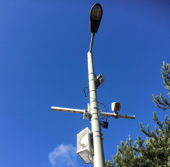
A lighting column in Suffolk packed with sensors
‘At the moment we measure it quite high; actually we want to start measuring it quite low. So can we actually fit the air quality monitors inside the street lighting columns, with certain ventilation methods, and start correlating between higher up air quality and lower down air quality monitors.
‘We are going to have bespoke lighting columns that will encapsulate the air quality monitor and make it so that the particulates can flow through accordingly.
‘We are also looking to use anemometers, measuring wind speed and wind direction, and take that data into account as well so looking at air quality and building up a holistic picture of it.’
The Suffolk project is also using sensors to monitor traffic levels, using two approaches. One is radar, which predominantly looks at counting vehicles but is not so good at classifying them.
‘But again as a compare and contrast,’ Mr Webster says, ‘we also have cameras and the cameras will differentiate between the types of road user and measure the volumes as well.’
The cameras use Artificial Intelligence to detect the types of vehicles. In compliance with GDPR, the system processes all the information on the [network] edge and sends packets of data across the network.
Like others involved in Live Labs, Mr Webster stresses that it needs to be seen as a way of finding out what works and what doesn’t, with the latter also proving valuable.
He says: ‘All the work we are doing is being reviewed by the University of Suffolk, and the university is writing a report on each piece of technology – the idea being that we have a business case that will support the technologies. However, we are under no illusions: some of them may not provide a very attractive business case. So it’s important that we share information nationally so people can see the steps that we’ve taken.’
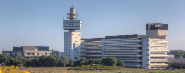
Adastral Park
In relation to the compare-and-contrast scenarios, Mr Webster explains: ‘What we are doing with the technology, rather than roll it straight out into the field, is use BT’s Adastral Park research facility [In Ipswich] to trial the sensors, almost like a head to head.
‘So if you take road sensors for example [used to inform winter service gritting potentially], we’re looking at the same piece of road, once we’re happy that the data is coming through correctly, and it’s reliable, we will then roll that out to the field, but it could be that some of the sensors are very expensive, some of them more cost-effective. So we need to look at how reliable and accurate they are. We are being very careful when we deploy them in the field to make sure we deploy them near weather stations, for example – that will then give us a controlled environment – and then start to locate them across several gritting routes.
‘We’re aware that across the county there could be a 10 degree variance in temperature. Obviously the more road surface temperature sensors we put in, the more granular the data will be. We are comparing – do we have in-ground sensors, do we have contactless sensors, do we have infra-red sensors?
'There’s a whole multitude of different sensor types and it’s trying to work out which is best in which environment. Suffolk gives us a very unique opportunity: we’ve got very heavily urban areas; we’ve got extremely rural area and we have coastal areas. So we are hoping that all the learning we have can be replicated throughout the UK.
‘We have [some road surface temperature sensors] on columns. We are looking at putting them into the roads or whether we can use neighbouring authorities’ information as they have them in the roads already. There is a lot of data sharing going on here as well.’
It is though, he says, too early to say whether one method is more accurate than another.
‘The trends are very similar. The actual points they are measuring can be a degree or so out, which can have a big impact on the winter service, because one degree can make the difference between going out on a [gritting] run and not going out on a run.
‘The idea is to operate the sensors this year alongside the current decision-making process and at the end of the season we can then compare and see, what would we have done differently, what would the savings have been and also how can this type of data be used to inform our decisions.
'We are currently making decisions quite a few hours before the run is due. So we are working with Meteo Group, who provide the weather forecasts, to see how we can make those insights and those interventions.’
The project is also trialling gulley sensors, which detect both silt levels and water flow. ‘We have sensor probes that go down and measure the silt and the water. And we have contactless sensors that measure water levels. It’s mounted under the grille.
'It sends a signal down and can measure how deep the water is. We have to go in beforehand to do depth measurements. We measure the depths of the outlet pipes and from that they can start sending that data through. But again it comes back to compare and contrast: is it important to measure the silt levels? We like to think it is, but then again the data might not bear that out. And then once we’ve got the data, how can that be translated for operational efficiencies?’
Like other projects, Suffolk’s Live Lab is interested not just in what individual sensors can tell it but in finding a way of collating and displaying information to make it accessible to decision-makers.
‘We are working with Meteo Group to see how we can ingest that data onto their dashboard. One of the important things throughout the whole of our project is that all these different sensors seem to have their own dashboard.
'And I don’t think as officers we have the time to go to every single dashboard to look at what each sensor is doing. An important point of the project is working with BT, as one of our key partners, they have designed and developed a single dashboard and they are then going to address all the different sensors, all the data, into one place. And that is obviously a key component of what we’re doing.’
The strapline really is: ‘Trying to revolutionise the services we deliver. That’s a key thing we are looking at through all this – how we can benefit the services to the public while also increasing operational efficiencies.’
Register now for full access
Register just once to get unrestricted, real-time coverage of the issues and challenges facing UK transport and highways engineers.
Full website content includes the latest news, exclusive commentary from leading industry figures and detailed topical analysis of the highways, transportation, environment and place-shaping sectors.
Use the link below to register your details for full, free access.
Already a registered? Login
