A new Android app developed by Strada Imaging in close collaboration with Aston University and Jacobs UK is designed to provide fast and accurate detailed visual inspection surveys.
About the app
Pavo is an Android app for detailed visual inspection (DVI) that can create a digital report with highly accurate editable maps and an inventory list of defects synchronised with the map data.
By facilitating smoother data collection, and ultra-fast processing, and making use of cloud-based technologies, Pavo makes an important contribution to the digitisation of transport infrastructure work.
Since November 2019, the app evolved thanks to its use in live projects and valuable feedback from the Asset Management Group at Jacobs UK Ltd.
Ryan Johnson, a senior pavement engineer at Jacobs, said: ‘The Pavo app literally allows us to execute our walk-in visual inspection in the usual way, but now with much more flexibility, as unlike paper-based surveys we could edit and delete defects.
'Our surveys, mostly performed in the wee hours, are much easier carrying a tablet alone, instead of the usual survey sheet, camera or smartphone, etc. Moreover, pen and paper surveys are always at the mercy of the elements, often leaving survey sheets with illegible records due to smeared ink from rain.
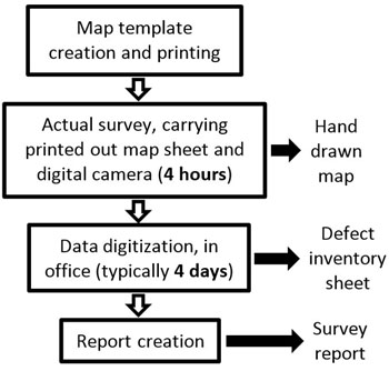
Figure 1
Figures 1 and 2 show process and time comparisons for (Figure 1) a paper-based survey where the surveyor spends about four hours on the road and (Figure 2) a Pavo routine, where the actual time spent on the road is cut down by at least 25%.
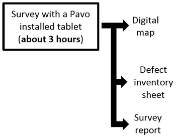
Figure 2
'The situation is much better with Pavo, where we can simply turn off the tablet’s screen and wipe it dry before continuing. At our suggestion, Strada Imaging built handwriting input and freehand sketching into the app, and we found that this killer feature improved the flexibility of the app further; we now can draw and write literally anything into the app directly.
'Pavo also has an intuitive user interface to the liking of my team at Jacobs. Automated digitisation, report generation, and emailing - all performed instantaneously - massively cut down the time and effort we usually spend on post-processing when we are back in the office. Pavo brings a breath of fresh air to our DVI.’
The team is now in the process of making Android and iOS apps for coarse visual inspection (CVI) for roads and visual surveys for airfields, industrial warehouses, ports, and other paved surfaces.
Features
The app makes use of the in-built sensors of smart devices, such as camera and GPS, to the advantage of data gathering, and its integrity and consistency. It can log complementary positional (i.e. stationing) data. Moreover, surveyors can immediately visualise the data they have recorded on the roadmap, and rectify any mistake immediately.
It also incorporates many predefined defects and features (e.g. side drain, lamp post), designed for a fast map and inventory generation. The software can take freehand sketches and writing as inputs.
Each defect record can be customized by adding detailed lateral position within the lane and a severity rating. The app also allows very adaptable lane configuration on the screen, giving greater flexibility to survey nearby lanes without the need for road closure.
The use of a tablet device's camera and labelling feature eliminates the need to carry a separate digital camera and the possibility of confusion and mistakes, which often happens in paper-based surveys.
The cloud-based data storage of the app also enables colleagues to shadow a survey from a remote location. The potential to produce digital data is a key time and money saving feature of the app, given that about 80% of overall paper-based survey time is spent in office, digitising data.
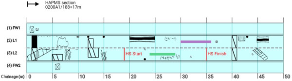
Figure 3. Road maps showing drawing functionality in Pavo
User interface
The user interface takes care of project settings and allows extensive customization for different types of lane configurations, such as road types and traffic directions. In addition, different lane types such as footways and cycle paths can be used to construct an accurate representation.
A given road portion can be flexibly segmented into sections for the purpose of recording, depending on the defect density.
Data storage and post-processing
The data collected from the app is securely hosted in the Google cloud platform for each survey, ensuring data privacy and protection. The app can also be easily connected to a user’s existing Google cloud account.
One of the key features of Pavo is its ‘live view’, whereby an authorised experienced surveyor can oversee the recordings of the field operation from a remote location. This collaborative approach can significantly increase survey efficiency.
Together with the survey report, an excel file with a list of recorded defects and features is also made, consisting of details such as their longitudinal location, lateral position, and severity levels. This file can then be used for maintenance planning.
Article by: Zain ul Mustafa, Muhammad Aamir, Khurram Kamal of Strada Imaging Ltd and
Mujib Rahman, Department of Civil Engineering, Aston University, Birmingham
For further details please contact, info@stradaimaging.com
Register now for full access
Register just once to get unrestricted, real-time coverage of the issues and challenges facing UK transport and highways engineers.
Full website content includes the latest news, exclusive commentary from leading industry figures and detailed topical analysis of the highways, transportation, environment and place-shaping sectors.
Use the link below to register your details for full, free access.
Already a registered? Login
